
Anúncios
Severe weather can strike unexpectedly, turning a calm day into a life-threatening situation. Knowing how to identify storm and hurricane risks is essential for your safety.


Whether you’re at home, traveling, or living in a hurricane-prone area, understanding weather patterns and warning signs can mean the difference between preparedness and panic. Modern technology has made it easier than ever to track dangerous weather systems before they reach your location.
Anúncios
This comprehensive guide will help you recognize the signs of approaching storms, understand hurricane classifications, and use available tools to stay informed. From meteorological indicators to smartphone apps, you’ll learn everything needed to protect yourself and your loved ones from nature’s most powerful forces. 🌪️
Understanding the Difference Between Storms and Hurricanes
Not all severe weather events are created equal. A thunderstorm, while potentially dangerous, differs significantly from a hurricane in terms of scale, duration, and destructive capacity. Thunderstorms typically last for short periods and affect localized areas, while hurricanes are massive rotating weather systems that can span hundreds of miles and persist for days or even weeks.
Anúncios
Hurricanes develop over warm ocean waters and are classified by sustained wind speeds. A tropical depression has winds below 39 mph, a tropical storm features winds between 39-73 mph, and a hurricane begins at 74 mph or higher. Understanding these classifications helps you gauge the severity of approaching weather and respond appropriately.
The terminology also varies by region. In the Atlantic and Northeast Pacific, these systems are called hurricanes. In the Northwest Pacific, they’re known as typhoons, while in the South Pacific and Indian Ocean, they’re called cyclones. Regardless of the name, the dangers remain consistent across all regions.
🌊 Recognizing Natural Warning Signs in Your Environment
Before modern forecasting existed, people relied on nature’s signals to predict severe weather. These indicators remain valuable today, especially when technology fails or is unavailable. A sudden drop in barometric pressure often precedes storms, which you might notice as an inexplicable headache or joint pain.
Watch for unusual animal behavior. Birds often fly lower before storms due to pressure changes, and many animals seek shelter hours before severe weather arrives. If you notice wildlife acting strangely or disappearing altogether, take it as a serious warning sign.
Cloud formations tell powerful stories. A greenish tint to the sky often indicates hail-producing storms. Mammatus clouds—those pouch-like formations hanging from cloud bases—frequently signal severe weather. A rapidly rotating wall cloud can spawn tornadoes, while bands of clouds spiraling inward suggest hurricane formation.
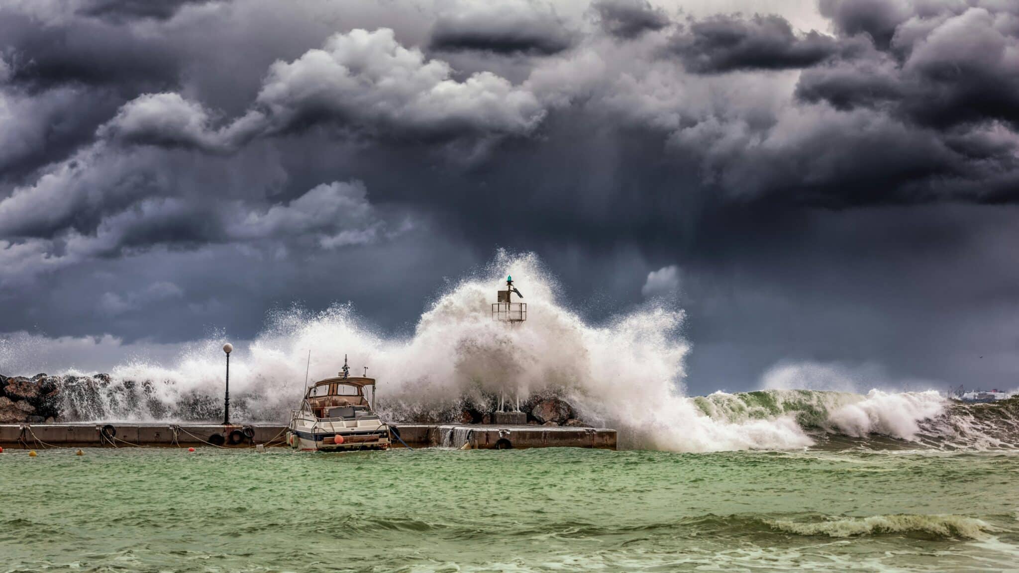
Ocean behavior changes dramatically before hurricanes. The surf may become unusually rough days before landfall, and water temperatures rise in specific patterns. Fishermen and coastal residents often notice these changes before official warnings are issued.
The Hurricane Classification System Explained
The Saffir-Simpson Hurricane Wind Scale provides a standardized method for rating hurricane intensity. This system helps emergency managers, meteorologists, and the public understand potential damage and necessary precautions.
Category 1 hurricanes feature winds of 74-95 mph. These storms cause damage to roofs, siding, and gutters. Branches break from trees, and power outages may last several days. While considered the weakest category, they still pose serious risks and require preparation.
Category 2 hurricanes bring winds of 96-110 mph. These storms cause extensive damage to roofs and siding, uproot shallow-rooted trees, and create prolonged power and water shortages. Mobile homes face severe damage risks.
Category 3 hurricanes reach winds of 111-129 mph and are considered major hurricanes. They cause devastating damage, removing roof decking and gable ends. Many trees snap or uproot, blocking roads. Electricity and water may be unavailable for weeks after the storm passes.
Category 4 hurricanes generate winds of 130-156 mph, causing catastrophic damage. Most of the affected area becomes uninhabitable for weeks or months. Severe structural damage affects well-built homes, and fallen trees isolate residential areas.
Category 5 hurricanes represent the ultimate threat, with winds exceeding 157 mph. These storms destroy a high percentage of framed homes, topple most trees and power poles, and render areas uninhabitable for months. Historically, only a handful of Category 5 storms have made landfall in the United States.

📱 Technology Tools for Storm Tracking and Alerts
Modern smartphone applications have revolutionized weather monitoring, putting powerful forecasting tools directly in your pocket. Dedicated hurricane tracking apps provide real-time updates on storm positions, projected paths, and intensity changes. These applications often include interactive radar, satellite imagery, and customizable alert systems.
Weather radio remains one of the most reliable alert systems, especially during power outages. NOAA Weather Radio broadcasts continuous weather information and automatically activates when warnings are issued for your area. Battery-powered or hand-crank models ensure functionality when electricity fails.
Social media has emerged as a valuable real-time information source during severe weather events. Following official meteorological agencies, emergency management offices, and local news stations provides instant updates. However, verify information from multiple credible sources before making critical decisions.
Satellite technology allows meteorologists to track hurricanes from formation through dissipation. Geostationary satellites provide continuous monitoring, while polar-orbiting satellites offer detailed atmospheric information. This data feeds computer models that project storm tracks and intensification patterns.
Understanding Weather Alerts and Warning Systems
Weather services issue different levels of alerts based on timing and certainty. A watch means conditions are favorable for severe weather development within the next 24-48 hours. This is your signal to review emergency plans and gather supplies.
A warning indicates that severe weather is occurring, imminent, or highly likely. Immediate protective action is necessary. For hurricanes, warnings typically arrive 36 hours before tropical storm-force winds are expected.
Advisories communicate less serious conditions that still require caution. These might include information about tropical storms that haven’t reached hurricane strength or post-storm flooding risks.
The Emergency Alert System (EAS) broadcasts critical warnings through television, radio, and mobile devices. Wireless Emergency Alerts (WEA) send geographically targeted messages to cell phones within affected areas, regardless of whether you have a weather app installed.
🏠 Creating Your Personal Storm Preparedness Plan
Preparation saves lives. Every household should develop and regularly practice an emergency plan specific to their location and risks. Identify the safest room in your home—typically an interior space on the lowest floor without windows.
Assemble an emergency kit containing water (one gallon per person per day for at least three days), non-perishable food, flashlights, batteries, first aid supplies, medications, copies of important documents in waterproof containers, and cash. Include pet supplies if you have animals.
Establish communication plans with family members. Designate an out-of-area contact person everyone can reach if local communications fail. Ensure all family members know meeting locations if you become separated.
Know your evacuation routes and have multiple options planned. Local authorities may close certain roads as storms approach, so flexibility is essential. If you live in an evacuation zone, never wait for mandatory evacuation orders—leaving early prevents getting trapped in dangerous conditions.
Secure your property before storms arrive. Install storm shutters or board up windows, bring outdoor furniture inside, trim trees and shrubs, and clear drainage systems. Photograph your property for insurance purposes before hurricanes strike.
Geographic Risk Zones: Where Hurricanes Strike Most Frequently
The Atlantic basin, including the Gulf of Mexico and Caribbean Sea, experiences the most hurricanes affecting North America. Florida, Louisiana, Texas, North Carolina, and South Carolina face the highest landfall risks. The Atlantic hurricane season officially runs from June 1 through November 30, with peak activity between mid-August and late October.
Pacific hurricanes affect Mexico’s west coast and occasionally reach Baja California and Southern California. While less frequent than Atlantic storms, Pacific hurricanes can be equally destructive when they make landfall in populated areas.
International hurricane zones include Southeast Asia, particularly the Philippines, Vietnam, and China, which experience typhoons regularly. The Indian Ocean cyclone season affects India, Bangladesh, and eastern Africa. Australia’s northern coast faces tropical cyclones during their summer months.
Even inland areas face hurricane-related dangers. These systems can travel hundreds of miles after landfall, bringing flooding rains, tornadoes, and damaging winds to regions far from coastlines. Historic storms have caused significant damage in places like Pennsylvania, New York, and even Vermont.
⚡ Immediate Actions When Danger Is Imminent
When a hurricane warning is issued for your area, time becomes critical. If evacuation orders are given, leave immediately. Traffic will worsen as more people decide to evacuate, and you may become trapped if you wait too long.
If remaining in place, move to your predetermined safe room. Close all interior doors and brace external doors. Stay away from windows even if they’re boarded or shuttered—flying debris can penetrate protective coverings.
Fill bathtubs and sinks with water for flushing toilets and washing if water service fails. Charge all electronic devices and turn refrigerators to their coldest settings before power loss. Turn off propane tanks and unplug small appliances to prevent damage from power surges when electricity returns.
Monitor weather reports continuously until the storm passes. Remember that the eye of a hurricane brings temporary calm, but devastating winds resume when the eye wall arrives. Never venture outside during the eye—the second half of the storm often proves more dangerous than the first.
After the storm passes, remain cautious. Downed power lines, contaminated water, structural damage, and wildlife displacement create numerous hazards. Wait for official all-clear announcements before leaving shelter, and report emergencies to authorities rather than attempting self-rescue operations.
Climate Change and Increasing Hurricane Intensity
Scientific research increasingly links climate change to hurricane behavior. Warmer ocean temperatures provide more energy for storm development and intensification. Studies show that while the total number of hurricanes may not increase dramatically, the proportion of major hurricanes (Category 3 and higher) is rising.
Sea level rise exacerbates storm surge impacts, pushing water farther inland and causing more extensive flooding. Coastal communities face compounding risks as both storm intensity and baseline water levels increase.
Rainfall rates from hurricanes are intensifying, with storms dropping more precipitation in shorter periods. This pattern creates catastrophic flooding even from weaker storms, as seen in recent events where tropical storms caused damage rivaling stronger hurricanes.
Understanding these trends helps with long-term planning. Coastal development decisions, infrastructure improvements, and insurance considerations must account for changing risk profiles. Individual preparedness takes on greater importance as extreme weather becomes more common.
🌐 Global Resources and International Alert Systems
Different regions maintain specialized meteorological agencies. In the United States, the National Hurricane Center (NHC) tracks Atlantic and Eastern Pacific storms. The Central Pacific Hurricane Center monitors the Central Pacific, while the Joint Typhoon Warning Center covers the Western Pacific and Indian Ocean for U.S. interests.
International travelers should familiarize themselves with local alert systems. Many countries use different warning criteria, terminology, and dissemination methods. Research emergency procedures for your destination before traveling during hurricane season.
The World Meteorological Organization coordinates international weather services and standardizes observational practices. This collaboration improves forecast accuracy and ensures consistent data sharing across borders.
Embassy and consulate websites provide country-specific emergency information for travelers. Register with your embassy when visiting hurricane-prone regions during storm season, enabling officials to contact you with critical safety information.
Mental Health and Stress Management During Weather Emergencies
Severe weather events create significant psychological stress. Anticipating danger, experiencing storms, and dealing with aftermath all challenge mental health. Recognizing these impacts helps you cope more effectively.
Maintain routines as much as possible during preparation and recovery phases. Regular meals, sleep schedules, and family activities provide stabilizing structure during chaotic periods. Limit continuous news consumption, which can increase anxiety without providing additional actionable information.
Children require special attention during weather emergencies. Explain situations honestly but age-appropriately. Include them in preparations to provide a sense of control and purpose. Maintain calm demeanors—children take emotional cues from adults.
Post-storm recovery often proves more stressful than the event itself. Dealing with property damage, insurance claims, displacement, and financial strain creates prolonged pressure. Don’t hesitate to seek professional mental health support if you’re struggling to cope. Many communities offer free counseling services after disasters.
🎯 Special Considerations for Vulnerable Populations
Elderly individuals face unique challenges during hurricanes. Limited mobility may complicate evacuations, while medication needs and medical equipment dependence require special planning. Establish support networks to check on elderly neighbors and family members before, during, and after storms.
People with disabilities need customized emergency plans. Consider mobility limitations, sensory impairments, and communication challenges when developing strategies. Register with local emergency management offices, which often maintain special needs registries and provide targeted assistance during evacuations.
Pet owners must plan for animal safety. Many emergency shelters don’t accept pets, so identify pet-friendly accommodations before evacuations become necessary. Maintain updated identification tags, microchip registrations, and medical records for all animals. Create pet emergency kits including food, water, medications, and comfort items.
Non-English speakers may struggle to receive timely warnings and understand emergency instructions. Seek weather information in your primary language through international news services, community organizations, or translation applications. Emergency management agencies increasingly provide multilingual resources recognizing diverse populations.
Learning From Historical Hurricanes and Their Lessons
Hurricane Katrina (2005) devastated New Orleans, revealing critical vulnerabilities in levee systems, evacuation planning, and emergency response coordination. The disaster prompted nationwide improvements in hurricane preparedness, though gaps remain.
Hurricane Maria (2017) caused catastrophic damage in Puerto Rico, where the storm’s slow movement and extreme rainfall created unprecedented flooding. The event highlighted infrastructure vulnerabilities and the challenges of island disaster response.
Hurricane Harvey (2017) stalled over Texas, dropping record-breaking rainfall that flooded Houston and surrounding areas. This storm demonstrated that rainfall and flooding can be more dangerous than winds in certain situations.
These historical events teach valuable lessons: earlier evacuations save lives, infrastructure resilience requires ongoing investment, and recovery takes far longer than most people anticipate. Studying past hurricanes helps individuals and communities better prepare for future events.
🔍 Staying Safe: Your Action Checklist
Knowing your risk is the foundation of hurricane safety. Determine if you live in an evacuation zone by checking with local emergency management offices. Understand your home’s elevation and flood risk using FEMA flood maps.
Download reliable weather tracking applications on your smartphone before hurricane season begins. Test alerts and familiarize yourself with app features during calm weather so you can navigate them easily during emergencies.
Build and maintain your emergency kit year-round. Check expiration dates on food, water, and medications regularly. Replace batteries and update important documents as circumstances change.
Participate in community preparedness activities. Attend emergency planning meetings, volunteer with local response organizations, and share knowledge with neighbors. Community resilience significantly improves individual safety outcomes.
Review and practice your family emergency plan at least twice yearly. Conduct drills that include evacuating your home, reaching safe rooms, and contacting designated emergency contacts. Practice builds muscle memory that functions even under stress.
Insurance and Financial Protection Strategies
Standard homeowners insurance typically doesn’t cover flood damage. Separate flood insurance through the National Flood Insurance Program or private insurers is necessary for comprehensive protection. Don’t wait until a storm approaches—flood insurance policies have 30-day waiting periods before taking effect.
Document your property and possessions through photographs and video before hurricane season. Store digital copies in cloud services accessible from any location. This documentation streamlines insurance claims and helps ensure appropriate compensation for losses.
Understand your insurance policy details, including deductibles, coverage limits, and excluded items. Hurricane deductibles often differ from regular deductibles, typically calculated as a percentage of home value rather than a flat amount.
Maintain emergency funds covering at least three to six months of expenses. Hurricanes can disrupt employment, create unexpected costs, and delay insurance payments. Financial reserves provide crucial stability during recovery periods.
The Future of Hurricane Forecasting and Prediction
Technological advances continuously improve forecast accuracy. Next-generation weather satellites provide higher resolution imagery and more frequent updates. Improved computer models better simulate storm behavior and predict intensification patterns.
Artificial intelligence and machine learning are being applied to hurricane prediction. These systems analyze vast datasets to identify subtle patterns that improve forecast accuracy, particularly for rapid intensification events that have historically challenged forecasters.
Hurricane hunter aircraft equipped with advanced instruments fly directly into storms, collecting data impossible to obtain through remote sensing. Unmanned aerial systems are being developed to supplement manned missions, providing more frequent and cost-effective observations.
Despite improvements, inherent unpredictability remains. Small atmospheric changes can significantly alter storm tracks and intensity. Forecasters work within these limitations, providing the best available information while acknowledging uncertainty. Understanding forecast limitations helps you make informed decisions without false confidence or unnecessary panic.
Staying safe during hurricanes and severe storms requires knowledge, preparation, and vigilance. By understanding warning signs, utilizing available technology, creating comprehensive emergency plans, and taking decisive action when danger approaches, you significantly improve your chances of weathering these powerful natural events safely. Remember that no property is worth your life—when authorities issue evacuation orders, leave immediately. Your preparation today determines your safety tomorrow when the skies darken and winds begin to howl. Stay informed, stay prepared, and stay safe wherever your journey takes you. 🌟

Toni Santos is a visionary artisan and conceptual designer who channels the beauty of living organisms into structural expression. At Zureste, Toni explores the intricate elegance of insect anatomy, organic flow, and bioinspired design to create art that feels both natural and otherworldly.
Each creation Toni brings to life reflects a harmonic tension between structure and softness, wildness and control — echoing the complex intelligence found in the natural world. From beetle-like silhouettes to root-shaped contours, his work blurs the lines between biology, sculpture, and modern art.
Guided by fascination for metamorphosis, evolution, and pattern in nature, Toni’s pieces embody transformation. His BioLight Collection and conceptual series like Insect Type and Structure Aesthetics offer viewers more than aesthetic value — they present immersive experiences of living design.
As the creative force behind Zureste, Toni invites us to rethink beauty, architecture, and identity through a new lens — one shaped by wings, bones, spirals, and the microscopic poetry of the organic.
His creations reflect:
-
Design deeply rooted in the geometry of life
-
Inspiration from insects, roots, and the unseen natural order
-
A blend of science, spirituality, and visual storytelling
Whether you’re a lover of strange beauty, an admirer of evolution’s artistry, or a creative mind seeking something different, Toni welcomes you into a world where living forms become meaning, and surreal becomes sublime.