
Anúncios
Satellite GPS and mapping technology have revolutionized how we navigate, explore, and understand our world in ways unimaginable just decades ago.


From the earliest days of human exploration, people have relied on the stars, compasses, and paper maps to find their way. Today, sophisticated satellite networks orbiting Earth provide pinpoint accuracy to billions of devices worldwide. This technological leap has transformed everything from daily commutes to emergency response systems, making location-based services an integral part of modern life.
Anúncios
Whether you’re hiking through unfamiliar terrain, driving to a new restaurant, or geotagging travel photos, satellite GPS technology works silently in the background. Understanding how these systems function and their practical applications can help you maximize their benefits while appreciating the remarkable engineering that makes them possible.
🛰️ How Satellite GPS Technology Actually Works
The Global Positioning System relies on a constellation of at least 24 operational satellites orbiting approximately 12,550 miles above Earth. These satellites continuously broadcast signals containing their precise location and the exact time the signal was transmitted. Your GPS receiver picks up signals from multiple satellites simultaneously—typically four or more—to calculate your exact position through a process called trilateration.
Anúncios
Each satellite completes two full orbits around Earth every day, ensuring that at least four satellites are visible from any point on the planet at any given time. This redundancy is crucial for accuracy and reliability. The atomic clocks aboard each satellite maintain incredibly precise timing, as even a microsecond error could translate to positioning errors of hundreds of feet.
When your device receives signals from multiple satellites, it measures the time delay between signal transmission and reception. Since radio waves travel at the speed of light, this time difference allows the device to calculate the distance to each satellite. With distances from four or more satellites, the GPS receiver can determine your three-dimensional position: latitude, longitude, and altitude.
📱 Modern Mapping Applications That Changed Everything
Contemporary mapping applications have evolved far beyond simple navigation tools. They’ve become comprehensive platforms that integrate real-time traffic data, business information, public transit schedules, and user-generated content. These applications leverage satellite GPS data combined with cellular tower triangulation and Wi-Fi positioning for enhanced accuracy, especially in urban environments where satellite signals may be partially obstructed.
Popular mapping platforms now offer features like offline map downloads, which allow users to navigate without cellular data—a game-changer for international travelers and outdoor enthusiasts. Street View imagery provides virtual exploration capabilities, helping users familiarize themselves with destinations before arrival. Real-time traffic updates reroute drivers around congestion, potentially saving hours of travel time weekly.
Features That Define Modern GPS Apps
- Turn-by-turn voice navigation: Hands-free guidance that keeps your eyes on the road
- Multi-stop route optimization: Automatically organizes multiple destinations in the most efficient order
- Live location sharing: Allows friends and family to track your journey in real-time
- Photo geotagging: Automatically embeds location data into your photographs
- Points of interest: Discover restaurants, gas stations, and attractions along your route
- Speed limit warnings: Helps drivers stay within legal speed limits
- Saved locations: Quick access to home, work, and frequently visited places
🌍 Beyond GPS: Other Global Navigation Satellite Systems
While GPS is the most well-known system, it’s not the only global navigation satellite system (GNSS) in operation. Russia operates GLONASS, which provides similar global coverage with its own constellation of satellites. The European Union’s Galileo system offers enhanced accuracy for civilian applications, while China’s BeiDou system has expanded from regional to global coverage in recent years.
Many modern smartphones and GPS receivers are multi-GNSS capable, meaning they can receive signals from multiple satellite systems simultaneously. This capability significantly improves positioning accuracy and reliability, particularly in challenging environments like dense urban areas or mountainous terrain where satellite visibility may be limited.
🚗 Practical Applications in Daily Life
Satellite navigation has seamlessly integrated into countless aspects of everyday life. Delivery services rely on GPS tracking to optimize routes and provide customers with real-time package location updates. Ride-sharing platforms match drivers with passengers and calculate fares based on GPS-tracked distances. Emergency services use location data to dispatch responders to incidents with remarkable speed and accuracy.
For outdoor enthusiasts, GPS technology has become an essential safety tool. Hikers can follow trails with confidence, knowing they can pinpoint their exact location even in remote wilderness areas. Geocaching has emerged as a popular recreational activity that turns GPS navigation into a worldwide treasure hunting game with millions of participants.
Professional Industries Transformed by GPS
Agriculture has experienced a revolution through precision farming techniques enabled by GPS technology. Farmers use satellite guidance systems to plant crops in perfectly straight rows, apply fertilizers and pesticides with pinpoint accuracy, and harvest with minimal waste. This precision reduces costs, increases yields, and minimizes environmental impact.
The aviation industry depends heavily on satellite navigation for flight planning, en-route navigation, and precision approaches to airports. Marine navigation similarly relies on GPS for safe passage through congested waterways and precise positioning during port operations. Surveying and construction professionals use GPS equipment to establish boundaries and guide heavy machinery with centimeter-level accuracy.
📸 Geotagging Photos: Capturing Memories with Location Context
Photo geotagging automatically embeds GPS coordinates into your digital images’ metadata, creating a permanent record of where each photo was taken. This feature has become incredibly valuable for organizing photo libraries, creating travel journals, and sharing location-specific content on social media platforms.
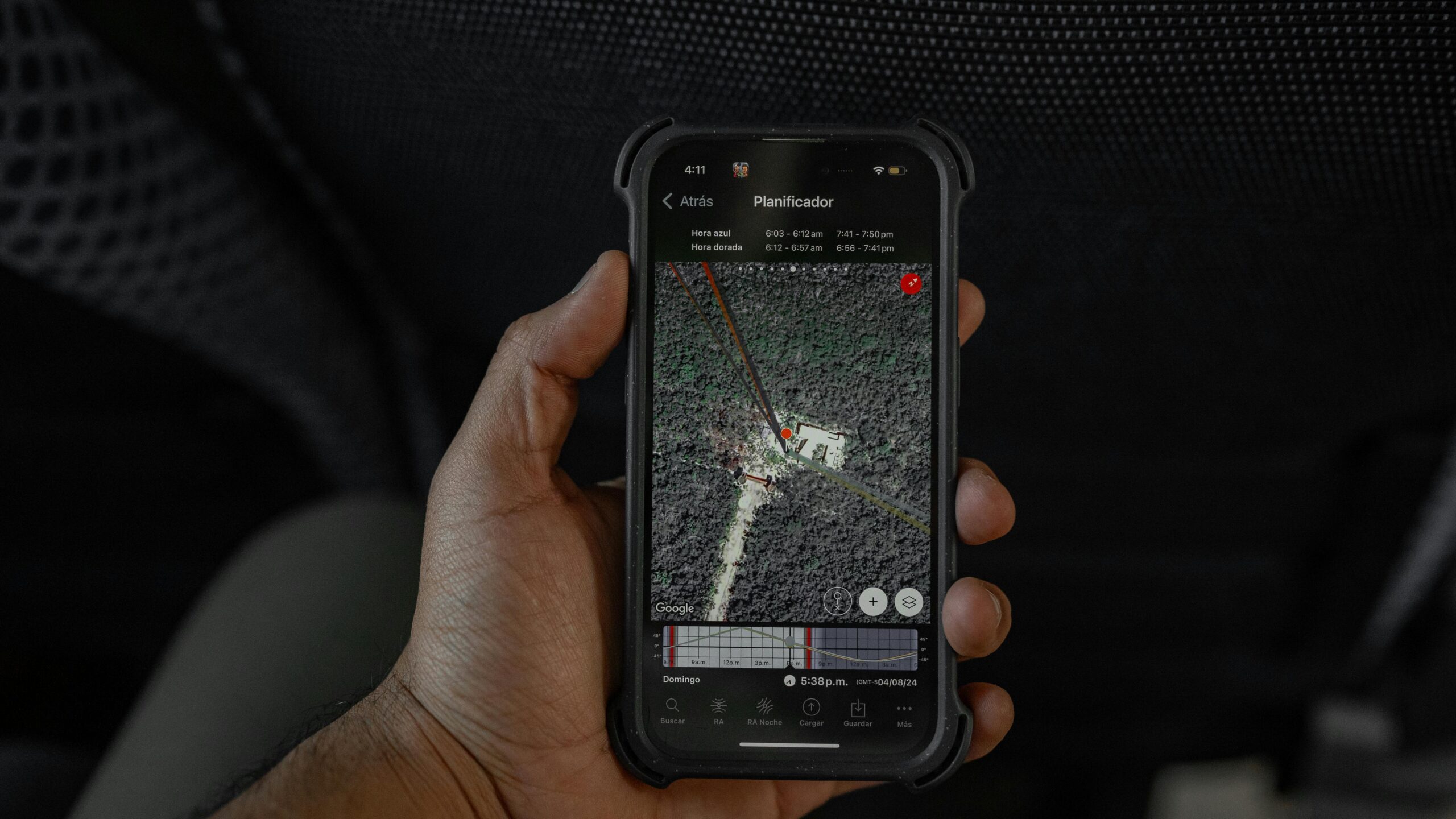
Specialized camera apps enhance this functionality by displaying your photos on interactive maps, allowing you to visualize your travels and revisit locations with ease. Some applications even create automatic travel timelines that chronicle your journeys through photo locations. This spatial organization method often proves more intuitive than traditional date-based sorting, especially when searching for photos from specific places.
Professional photographers use geotagged images to document field research, real estate properties, and landscape photography locations. The ability to return to exact shooting locations for different lighting conditions or seasonal variations provides creative flexibility that was previously difficult to achieve without meticulous manual record-keeping.
🔒 Privacy Considerations and Location Data
While GPS technology offers tremendous convenience, it also raises important privacy considerations. Location data reveals sensitive information about your daily routines, frequented locations, and personal relationships. Many applications request location access, but users should carefully consider whether each app genuinely needs this information for its core functionality.
Modern smartphones offer granular location permission controls, allowing users to grant access only while using an app, deny access entirely, or provide approximate rather than precise location. Regularly reviewing which applications have location permissions and understanding how they use this data helps maintain privacy while still enjoying location-based services.
Photo sharing on social media platforms automatically includes geotagged location data unless specifically disabled, potentially revealing your home address or current whereabouts to unwanted audiences. Many security experts recommend removing location data from photos before sharing them publicly, especially images taken at your residence or showing vulnerable individuals like children.
🎯 Improving GPS Accuracy and Performance
Several factors influence GPS accuracy, and understanding them helps users get the best possible performance from their devices. Clear sky visibility is crucial—buildings, tree canopy, and terrain can block satellite signals and reduce accuracy. Starting your GPS app outdoors in an open area allows faster satellite acquisition and better initial positioning.
Assisted GPS (A-GPS) technology uses cellular network data to speed up satellite acquisition time dramatically. When your phone downloads satellite orbital data from cell towers, it can determine which satellites should be visible and lock onto signals much faster than traditional GPS receivers that must search the entire sky.
Tips for Optimal GPS Performance
- Enable high accuracy mode: Uses GPS, Wi-Fi, and cellular networks for best positioning
- Keep your device updated: Software updates often include GPS performance improvements
- Calibrate your compass: Move your phone in a figure-8 pattern to improve directional accuracy
- Remove protective cases: Some metallic cases can interfere with GPS signal reception
- Allow warm-up time: GPS accuracy improves after a few minutes as more satellites are acquired
- Check battery settings: Some power-saving modes reduce GPS refresh rates
🗺️ Offline Maps: Navigation Without Connectivity
Offline mapping capabilities have become essential features for travelers, outdoor adventurers, and anyone venturing into areas with limited cellular coverage. By downloading map data in advance, users can access full navigation features without requiring an internet connection. This functionality proves invaluable when traveling internationally to avoid expensive roaming charges or exploring remote wilderness areas.
The technology works by storing detailed map tiles, routing algorithms, and points of interest data directly on your device. While the GPS receiver still needs satellite signals to determine your position, all mapping and routing calculations happen locally on your device. Some applications allow users to download entire countries or regions, while others focus on specific areas to conserve storage space.
Offline maps require periodic updates to reflect road changes, new businesses, and updated points of interest. Most mapping applications make this process seamless, automatically updating downloaded regions when connected to Wi-Fi. The storage requirements have decreased substantially as compression algorithms improve, making it practical to keep multiple regions downloaded simultaneously.
🌟 Future Developments in Satellite Navigation
The next generation of GPS satellites, known as GPS III, promises significant improvements in accuracy, signal strength, and resistance to interference. These advanced satellites will provide better performance in urban canyons and challenging environments while offering enhanced security features to prevent spoofing and jamming attempts.
Augmented reality navigation represents an emerging frontier that overlays directional arrows and information directly onto live camera views through your smartphone screen. This intuitive visual guidance helps pedestrians navigate complex urban environments, making it easier to identify the correct street, building entrance, or public transit station.
Indoor positioning systems are rapidly developing to extend location-based services into buildings where traditional GPS signals cannot penetrate. Using a combination of Wi-Fi, Bluetooth beacons, and magnetic field mapping, these systems enable navigation inside shopping malls, airports, museums, and office buildings with impressive accuracy.
🏃 Fitness Tracking and Location Services
GPS technology has revolutionized personal fitness tracking, enabling runners, cyclists, and outdoor athletes to monitor distance, pace, elevation gain, and route profiles with remarkable precision. Wearable devices and smartphone applications record detailed workout data that helps users set goals, track progress, and share achievements with communities of like-minded enthusiasts.
Route recording features allow athletes to document their favorite trails, discover popular routes in new areas, and revisit successful training locations. Many fitness platforms incorporate social features where users can compete on virtual leaderboards for specific segments, adding a competitive element to solo training sessions.
Safety features like live location sharing during workouts provide peace of mind for both athletes and their loved ones. If an emergency occurs during a remote trail run or long-distance cycling ride, emergency contacts can immediately see the athlete’s exact location and movement history.
💡 Maximizing Value from GPS Camera and Mapping Apps
Specialized applications that combine GPS mapping with camera functionality offer unique advantages for travelers, photographers, and memory-keepers. These apps automatically organize photos by location, create visual travel journals, and help users rediscover forgotten adventures through location-based browsing.
The ability to see all photos taken at a specific location proves invaluable when planning return visits or sharing recommendations with friends. Location-based photo albums automatically group images from the same restaurant, landmark, or vacation destination, creating natural collections without manual sorting.
Advanced features like route tracking coupled with photo timestamps allow users to create comprehensive travel documentaries. The application can display your exact path throughout a day of sightseeing, marked with photos taken at each stop. This chronological-spatial record becomes a cherished memento that captures not just what you saw, but the journey between each destination.
🔧 Troubleshooting Common GPS Issues
When GPS performance falls short of expectations, several common issues might be responsible. Software glitches can often be resolved by simply closing and restarting the mapping application, or in persistent cases, restarting the device entirely. Clearing the app’s cache sometimes resolves issues with outdated map data or corrupted location files.
Physical obstructions like being inside buildings, under dense tree cover, or in deep urban canyons between tall buildings naturally degrade GPS performance. Moving to an area with better sky visibility typically resolves these issues. Electromagnetic interference from certain electronic devices can also affect GPS receivers, though this is less common with modern shielded components.
If your device consistently shows inaccurate locations or slow satellite acquisition times, checking for system updates should be your first step. Manufacturers regularly release improvements to GPS firmware and location services. Additionally, ensuring that location services are enabled in your device settings and that the specific application has appropriate permissions prevents access-related issues.

🌐 The Social Impact of Universal Navigation
Satellite GPS and mapping technology have democratized navigation in profound ways. People who previously struggled with spatial orientation or reading traditional maps now navigate confidently using turn-by-turn guidance. This accessibility empowerment extends independence to individuals who might otherwise feel anxious about traveling to unfamiliar locations.
Economic opportunities have expanded as location-based services enable new business models. The gig economy relies heavily on GPS for delivery, ride-sharing, and service dispatch. Small businesses benefit from appearing in location-based searches, helping local establishments compete with larger chains by capturing customers actively searching for nearby services.
Humanitarian applications have saved countless lives through emergency response coordination, disaster relief logistics, and search-and-rescue operations. When natural disasters strike, GPS technology helps coordinate volunteer efforts, locate survivors, and deliver supplies to affected areas with unprecedented efficiency.
The fusion of satellite technology and mapping applications has fundamentally altered how humans interact with their environment. What once required paper maps, compasses, and considerable navigational skill now happens effortlessly through devices we carry in our pockets. As technology continues advancing, the accuracy, reliability, and applications of GPS systems will only expand, further integrating location awareness into the fabric of daily life. Whether navigating city streets, exploring wilderness trails, or simply documenting life’s moments with location context, satellite GPS technology empowers us to explore confidently and remember vividly where our adventures take us. 🌏✨

Toni Santos is a visionary artisan and conceptual designer who channels the beauty of living organisms into structural expression. At Zureste, Toni explores the intricate elegance of insect anatomy, organic flow, and bioinspired design to create art that feels both natural and otherworldly.
Each creation Toni brings to life reflects a harmonic tension between structure and softness, wildness and control — echoing the complex intelligence found in the natural world. From beetle-like silhouettes to root-shaped contours, his work blurs the lines between biology, sculpture, and modern art.
Guided by fascination for metamorphosis, evolution, and pattern in nature, Toni’s pieces embody transformation. His BioLight Collection and conceptual series like Insect Type and Structure Aesthetics offer viewers more than aesthetic value — they present immersive experiences of living design.
As the creative force behind Zureste, Toni invites us to rethink beauty, architecture, and identity through a new lens — one shaped by wings, bones, spirals, and the microscopic poetry of the organic.
His creations reflect:
-
Design deeply rooted in the geometry of life
-
Inspiration from insects, roots, and the unseen natural order
-
A blend of science, spirituality, and visual storytelling
Whether you’re a lover of strange beauty, an admirer of evolution’s artistry, or a creative mind seeking something different, Toni welcomes you into a world where living forms become meaning, and surreal becomes sublime.