

Anúncios
Measuring land accurately has never been easier thanks to modern GPS technology that puts professional-grade surveying tools right in your pocket.


Whether you’re planning to purchase a countryside property, divide land among family members, or simply need to calculate how much fencing material you’ll need for your ranch, knowing the exact measurements of your terrain is essential.
Anúncios
Traditional surveying methods can be expensive and time-consuming, requiring professional equipment and expertise that isn’t always accessible to everyone.

GPS-based mapping applications have revolutionized how property owners, farmers, real estate agents, and land developers approach land measurement. These innovative tools leverage satellite positioning technology to deliver precise area calculations and perimeter measurements without the need for costly surveying equipment or professional services. 📱
Anúncios
Why GPS Mapping Apps Are Essential for Property Owners
Gone are the days when measuring land required walking the entire perimeter with measuring wheels or hiring expensive surveyors for preliminary assessments. GPS technology has democratized land measurement, making it accessible to anyone with a smartphone. These applications use the same satellite network that powers navigation systems worldwide, providing accuracy levels that are suitable for most practical purposes.
For rural property owners, the ability to quickly measure fields, pastures, and wooded areas helps with agricultural planning, irrigation system design, and crop rotation strategies. Real estate professionals can provide immediate property size estimates during site visits, enhancing their service offerings and speeding up transaction processes.
The financial implications are significant too. Before committing to professional surveying services that can cost hundreds or even thousands of dollars, property owners can conduct preliminary measurements to understand what they’re working with. This initial assessment helps in budgeting, planning, and decision-making processes.
How GPS Area Measurement Actually Works 🛰️
Understanding the technology behind these applications helps users appreciate their capabilities and limitations. GPS devices receive signals from multiple satellites orbiting Earth, typically requiring signals from at least four satellites to calculate an accurate position. The more satellites your device can connect with, the more precise your measurements become.
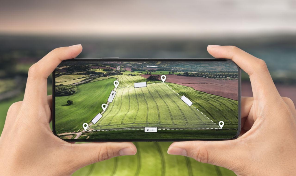
When you walk the perimeter of your property with a GPS measurement app running, the application records coordinate points at regular intervals. These waypoints create a digital boundary that the software then uses to calculate both the enclosed area and the total perimeter distance. Advanced algorithms account for the Earth’s curvature and terrain variations to provide measurements in various units.
Modern smartphones contain remarkably sophisticated GPS chips that can achieve accuracy within 3-5 meters under optimal conditions. When combined with assisted GPS (A-GPS) technology that uses cellular networks to improve satellite acquisition, these measurements become even more reliable for practical applications.
Factors That Affect GPS Measurement Accuracy
Several environmental and technical factors influence how accurately you can measure land using GPS technology. Understanding these variables helps you optimize your measurement sessions and interpret results correctly.
Atmospheric conditions play a crucial role in signal quality. Cloud cover, humidity, and ionospheric activity can all affect how GPS signals travel from satellites to your device. Generally, clear weather conditions provide the best measurement opportunities, though modern GPS technology compensates well for most atmospheric interference.
Physical obstructions present more significant challenges. Dense forest canopies, tall buildings, steep canyon walls, and even your own body can block satellite signals. For best results when measuring wooded properties, try to maintain clear sight lines to the sky by walking along established paths or clearings when possible.
Device quality matters too. While most modern smartphones have capable GPS receivers, some devices perform better than others. Keeping your device’s software updated ensures you’re using the latest positioning algorithms and satellite data.
Practical Applications for Different Property Types 🏡
The versatility of GPS measurement apps makes them valuable tools across various property categories, each with unique requirements and challenges.
Rural Farms and Ranches
Agricultural operations benefit enormously from GPS area measurement capabilities. Farmers can quickly calculate field sizes for crop planning, determining exactly how much seed, fertilizer, or pesticide to purchase. This precision reduces waste and optimizes input costs, directly impacting profitability.
Ranchers use these tools to measure pasture areas for rotational grazing systems, ensuring livestock has adequate forage without overgrazing. When installing fencing, accurate perimeter measurements prevent costly material shortages or excess purchases. Water resource planning also becomes more efficient when you know precisely how much acreage needs irrigation coverage.
Residential Lots and Building Sites
Homeowners and prospective buyers use GPS measurement apps to verify property boundaries and lot sizes before purchasing land. While these measurements shouldn’t replace professional surveys for legal purposes, they provide valuable preliminary information that can identify discrepancies or confirm advertised dimensions.
Landscaping projects become easier to plan when you know exactly how much area you’re working with. Whether you’re calculating sod requirements, planning garden beds, or designing outdoor living spaces, accurate measurements eliminate guesswork and reduce material waste.
Recreational Properties and Hunting Land
Outdoor enthusiasts who own hunting properties or recreational land use GPS measurement tools to track trail systems, identify prime locations for food plots, and understand their property’s layout for management purposes. Conservation easements and wildlife habitat restoration projects require accurate acreage calculations that these apps readily provide.
Step-by-Step Guide to Measuring Your Property 📍
Getting accurate measurements with GPS apps requires following some best practices and understanding the proper techniques.
Preparation Phase: Before heading out to measure your property, ensure your smartphone is fully charged, as GPS usage drains batteries quickly. Download offline maps of your area if your app supports this feature, which is especially useful for remote properties with limited cellular coverage. Identify your property corners or boundaries using existing markers, fences, or survey stakes.
Initial Setup: Launch your GPS measurement application and allow it time to acquire satellite signals. Most apps display signal strength indicators showing when you’ve achieved sufficient satellite lock for accurate measurements. This initial acquisition can take anywhere from 30 seconds to several minutes depending on conditions.
Walking the Perimeter: Begin at a clearly identifiable starting point, such as a property corner or gate. Start the recording function in your app and walk steadily along your property boundary. Maintain a consistent pace—neither too fast nor unnecessarily slow. The app will automatically record waypoints as you move, creating a digital trace of your path.
Handling Obstacles: When you encounter obstacles like ponds, buildings, or dense vegetation, stay as close to the actual boundary as safely possible. Most apps allow you to pause recording if you need to navigate around hazards, then resume from where you left off.
Completing the Measurement: Return to your starting point to close the polygon. Most applications will automatically connect the last point to the first, creating a complete boundary. Review the displayed area and perimeter measurements, which typically appear in multiple units such as acres, hectares, square feet, and meters.
Tips for Maximum Accuracy ✨
Professional land measurers follow certain protocols to achieve the best results, and you can too:
- Measure during optimal conditions—mid-morning to mid-afternoon on clear days typically provides the best satellite visibility
- Hold your device away from your body at chest height to minimize signal interference
- Walk at a steady, moderate pace to ensure consistent waypoint spacing
- Avoid measuring during heavy storms or immediately following rain when atmospheric moisture is highest
- Consider taking multiple measurements on different days and averaging the results for important projects
- Calibrate your device’s compass if your app offers this feature, improving directional accuracy
- Remove phone cases that contain metal components, which can interfere with GPS signals
Understanding Your Measurement Results 📊
Once you’ve completed a measurement, interpreting the data correctly ensures you can apply it effectively to your planning needs.
Most GPS measurement apps provide results in multiple unit systems simultaneously. In the United States, you’ll typically see acres and square feet, while international users might prefer hectares or square meters. Understanding these conversions helps you communicate with contractors, suppliers, and other stakeholders who may use different measurement standards.
Perimeter measurements serve different purposes than area calculations. While area tells you the total size of your property, perimeter information is crucial for fencing projects, boundary marking, or understanding the walking distance around your land. Some apps also calculate the distance between specific points, useful for planning driveways, utility runs, or irrigation lines.
Margin of Error Considerations
Consumer GPS technology typically achieves accuracy within 3-5 meters (10-16 feet) under good conditions. For large properties, this margin of error represents a small percentage of total area. A 5-meter error on a 10-acre property affects less than 1% of the total measurement.
However, for smaller lots or precise applications, this margin becomes more significant. A 5-meter error could represent 5-10% of the measurement on a half-acre lot. Understanding these limitations helps you decide when GPS measurements are sufficient and when professional surveying becomes necessary.
Beyond Basic Measurement: Advanced Features 🔧
Modern GPS mapping applications offer functionality that extends far beyond simple area calculation, providing comprehensive land management tools.
Many apps include the ability to save multiple measurements and organize them into projects or properties. This feature proves invaluable for managing multiple parcels, tracking changes over time, or maintaining records for different sections of a large property. You can create digital libraries of your land measurements that remain accessible for future reference.
Export and sharing capabilities allow you to send measurement data to others or import it into professional surveying software, CAD programs, or GIS systems. Common export formats include KML files for Google Earth, GPX for GPS devices, and PDF reports for documentation purposes.
Photo documentation features let you attach images to specific waypoints or entire properties, creating visual records of boundary markers, features, or conditions at the time of measurement. This visual documentation can be invaluable for insurance purposes, legal documentation, or simply remembering what you observed during your measurement session.
Integration with Other Planning Tools
Some advanced applications integrate measurement capabilities with planning and design features. You might draw proposed fencing layouts, plot locations for buildings or structures, or design irrigation systems directly within the app. These integrated tools transform your measurement app from a simple calculator into a comprehensive property management platform.
Legal Considerations and Limitations ⚖️
While GPS measurement apps provide valuable information for planning and estimation, understanding their legal standing is crucial for property owners.
GPS measurements from smartphone applications should never replace professional surveys for legal purposes such as property transactions, boundary disputes, or official documentation. Licensed surveyors use specialized equipment with significantly higher precision and follow rigorous protocols that create legally defensible records.
However, GPS apps excel in preliminary assessments, planning activities, and everyday property management tasks where legal precision isn’t required. They’re perfect for estimating materials needed, planning projects, or getting general property information before investing in professional services.
Some jurisdictions have specific requirements about property measurements for permit applications, subdivision requests, or zoning compliance. Always verify local regulations before relying on GPS measurements for official submissions.
Choosing the Right GPS Measurement App 📲
The marketplace offers numerous GPS area measurement applications, each with different features, capabilities, and pricing models. Selecting the right tool depends on your specific needs and usage frequency.
Free versions of many apps provide basic measurement functionality suitable for occasional users or simple projects. These typically include area and perimeter calculations with standard unit conversions. Premium or paid versions unlock advanced features like unlimited saved measurements, export capabilities, photo attachments, and customer support.
User interface design significantly impacts usability, especially for people who aren’t technically inclined. Look for apps with intuitive controls, clear visual displays, and helpful tutorials or guides. Reading user reviews provides insights into real-world performance and reliability that marketing materials might not reveal.
Battery efficiency matters for large property measurements that require extended GPS use. Some applications optimize power consumption better than others, allowing you to complete measurements without draining your device completely.
Real-World Success Stories 🌟
Property owners across various sectors have discovered how GPS measurement apps solve practical problems and create new opportunities.
A hobby farmer in rural Texas used a GPS measurement app to accurately calculate his pasture areas, enabling him to optimize his rotational grazing system. By knowing precisely how much forage each paddock contained, he improved livestock health while reducing hay costs by 30%. The simple act of accurate measurement transformed his operation’s efficiency.
A real estate developer in Oregon employed GPS mapping during preliminary site assessments, quickly evaluating dozens of potential properties without incurring survey costs upfront. This screening process saved thousands of dollars by eliminating unsuitable parcels early in the evaluation process, before committing to expensive professional surveys.
An environmental conservation organization used GPS area measurement tools to document wetland restoration projects, tracking habitat expansion and creating compelling reports for grant applications. The visual maps and precise measurements helped secure additional funding by demonstrating measurable progress and professionalism.
Future Developments in GPS Measurement Technology 🚀
The evolution of satellite positioning technology continues accelerating, promising even better capabilities for property measurement applications in coming years.
New satellite constellations from various countries and private companies are expanding coverage and improving accuracy worldwide. The European Galileo system, Russia’s GLONASS, China’s BeiDou, and commercial satellite networks all contribute additional signals that modern devices can utilize for enhanced positioning precision.
Augmentation systems that transmit correction data to improve GPS accuracy are becoming more accessible to consumer devices. These systems can reduce positioning errors to centimeter-level precision, approaching professional survey-grade accuracy without specialized equipment.
Artificial intelligence and machine learning algorithms are being integrated into measurement applications, automatically compensating for errors, identifying anomalies, and optimizing measurement techniques based on environmental conditions. These smart features make accurate measurements accessible to users with no technical expertise.
Maximizing Your Investment in GPS Measurement Tools 💡
Getting the most value from GPS measurement applications requires approaching them as part of a comprehensive property management strategy rather than isolated tools.
Regular measurements track changes over time, documenting property evolution and creating valuable historical records. Annual measurements of cultivated areas, pastures, or managed forests provide data for identifying trends, supporting improvement claims, or demonstrating stewardship for conservation programs.
Combining GPS measurements with photo documentation creates comprehensive property records useful for insurance, taxes, or future planning. Taking dated photos at waypoints or property corners alongside measurements builds a visual timeline of your land.
Sharing measurements with contractors, suppliers, or service providers ensures everyone works from the same accurate information. This coordination prevents miscommunications, material shortages, or cost overruns that result from inaccurate estimates.
Making Informed Property Decisions With Confidence 🎯
The power to accurately measure your land using GPS technology represents more than just convenience—it’s about empowerment and informed decision-making. Whether you’re managing a small residential lot or thousands of acres of agricultural land, understanding your property’s true dimensions provides the foundation for effective planning and management.
These measurement tools have transformed from professional-only equipment costing thousands of dollars into accessible smartphone applications available to everyone. This democratization of land measurement technology enables property owners to take control of their land management activities, reduce reliance on expensive services for routine tasks, and make decisions based on accurate data rather than estimates.
The combination of satellite technology, mobile computing power, and user-friendly software has created an unprecedented opportunity for property owners worldwide. From fencing calculations to crop planning, from property verification to conservation documentation, GPS measurement apps serve countless practical purposes that justify their place as essential tools in every landowner’s digital toolkit.
Start exploring GPS measurement capabilities today, and discover how precise property knowledge transforms the way you interact with and manage your land. The investment of time learning these tools pays dividends through better planning, reduced costs, and the confidence that comes from knowing exactly what you’re working with. Your property deserves accurate measurement—and now you have the technology to provide it. 🌍

Toni Santos is a visionary artisan and conceptual designer who channels the beauty of living organisms into structural expression. At Zureste, Toni explores the intricate elegance of insect anatomy, organic flow, and bioinspired design to create art that feels both natural and otherworldly.
Each creation Toni brings to life reflects a harmonic tension between structure and softness, wildness and control — echoing the complex intelligence found in the natural world. From beetle-like silhouettes to root-shaped contours, his work blurs the lines between biology, sculpture, and modern art.
Guided by fascination for metamorphosis, evolution, and pattern in nature, Toni’s pieces embody transformation. His BioLight Collection and conceptual series like Insect Type and Structure Aesthetics offer viewers more than aesthetic value — they present immersive experiences of living design.
As the creative force behind Zureste, Toni invites us to rethink beauty, architecture, and identity through a new lens — one shaped by wings, bones, spirals, and the microscopic poetry of the organic.
His creations reflect:
-
Design deeply rooted in the geometry of life
-
Inspiration from insects, roots, and the unseen natural order
-
A blend of science, spirituality, and visual storytelling
Whether you’re a lover of strange beauty, an admirer of evolution’s artistry, or a creative mind seeking something different, Toni welcomes you into a world where living forms become meaning, and surreal becomes sublime.