
Anúncios
Measuring outdoor spaces accurately is essential for construction, landscaping, agriculture, and property development, and combining GPS technology with calculation tools makes this process faster and more reliable than ever before.


Whether you’re a contractor planning a building site, a farmer assessing crop fields, or a homeowner designing outdoor renovations, having precise measurements can save time, money, and prevent costly errors.
Anúncios
Traditional methods like tape measures and manual surveying are time-consuming and prone to inaccuracies, especially over large or irregular terrain.

Modern technology has revolutionized field measurement by integrating GPS satellites with sophisticated calculation algorithms directly into mobile devices. These tools provide professional-grade accuracy while remaining accessible to anyone with a smartphone, transforming how we approach outdoor spatial planning and measurement tasks. 📱
Anúncios
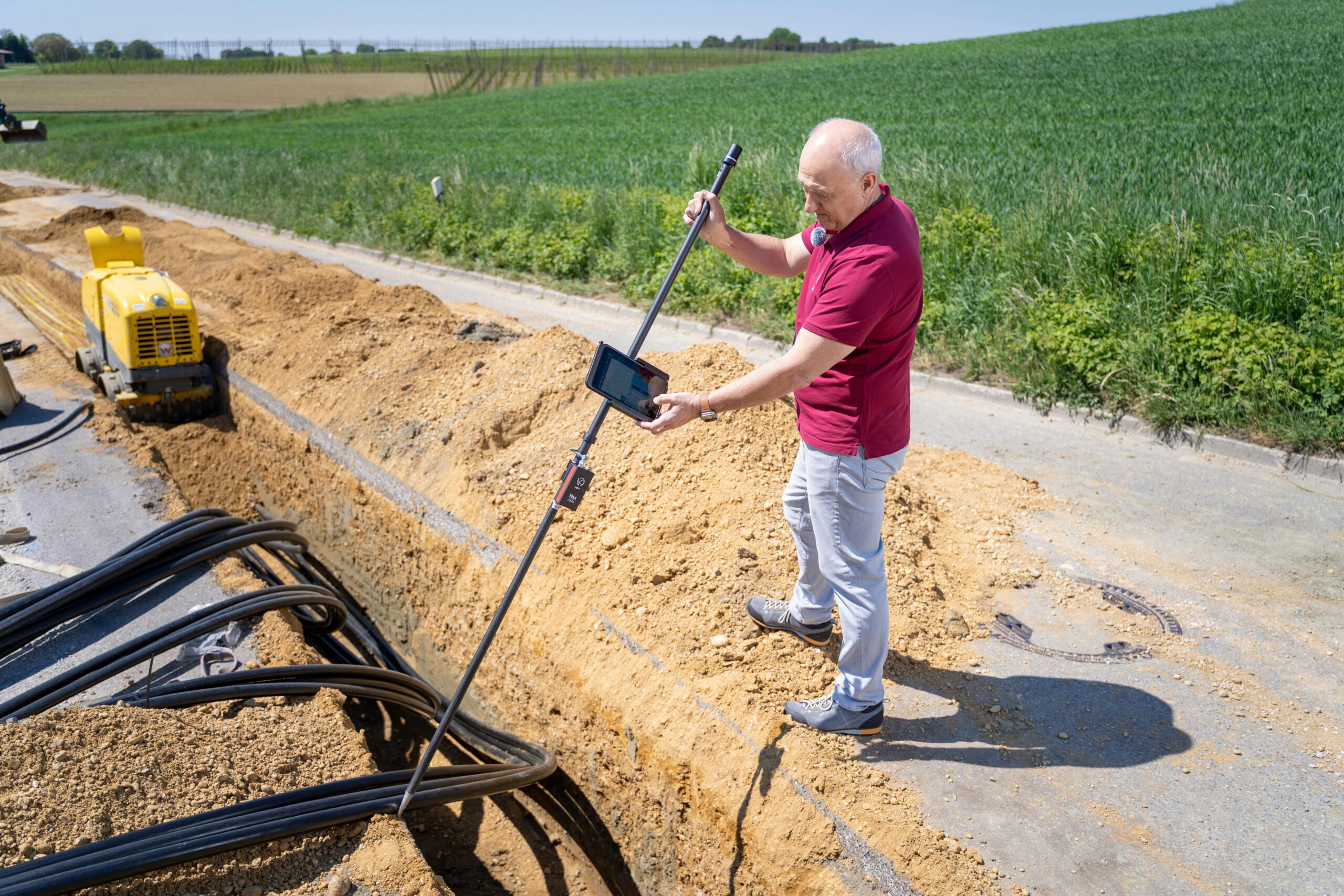
Why GPS-Based Area Measurement Matters for Construction Projects
Construction planning requires exact measurements from the very beginning. Even small discrepancies in land area calculations can lead to material shortages, budget overruns, and project delays. GPS-based measurement tools eliminate guesswork by providing coordinates accurate to within a few meters or even centimeters with advanced systems.
Traditional surveying requires specialized equipment and trained professionals, which can be expensive and time-consuming. GPS measurement apps democratize this process, allowing contractors and project managers to perform preliminary assessments quickly. This doesn’t replace professional surveys for legal purposes but provides valuable data for initial planning stages.
For residential construction, knowing the exact buildable area helps architects design homes that maximize usable space while complying with local zoning regulations. Commercial developers can assess multiple potential sites quickly, comparing sizes and configurations before committing to expensive land surveys. ⚡
How GPS Technology Calculates Outdoor Areas
GPS measurement works by receiving signals from multiple satellites orbiting Earth. Your device calculates its position based on the time signals take to arrive from different satellites. As you walk the perimeter of an area, the app records coordinate points and connects them to form a polygon.
The calculation engine then applies geometric formulas to determine the enclosed area. For simple rectangular plots, this involves basic multiplication, but for irregular shapes, the software uses advanced algorithms like the Shoelace formula or triangulation methods to compute accurate results regardless of shape complexity.
Modern GPS measurement apps enhance accuracy through differential GPS techniques, which compare your device’s readings against fixed reference stations. Some applications also incorporate augmented reality features, overlaying measurement data onto your phone’s camera view for intuitive visualization.
Understanding GPS Accuracy Limitations
Consumer GPS devices typically achieve accuracy within 3-10 meters under open sky conditions. Factors affecting precision include satellite visibility, atmospheric conditions, and physical obstructions like buildings or dense tree cover. Professional-grade GPS receivers can achieve centimeter-level accuracy but cost significantly more.
For most construction and landscaping projects, standard smartphone GPS provides sufficient accuracy for preliminary planning. The key is understanding when professional surveying is necessary—typically for legal boundary determinations, mortgage requirements, or projects where millimeter precision matters.
Essential Features in GPS Area Measurement Tools
The best measurement applications combine GPS functionality with practical calculation features. Look for tools that allow you to mark waypoints as you walk a perimeter, automatically connecting points to form boundaries. The ability to save and label multiple measurements proves invaluable when comparing different sites or tracking project progress.
Unit conversion functionality is essential since construction projects may require measurements in various formats—square feet, acres, hectares, or square meters. Instant conversion eliminates calculation errors and facilitates communication between teams working in different measurement systems.
Advanced tools offer distance measurement between any two points, perimeter calculations, and the ability to create complex shapes with multiple boundaries. Some applications also calculate slope angles and elevation changes, which are critical for drainage planning and foundation work. 🛠️
Data Export and Sharing Capabilities
Professional workflows require seamless data transfer between field measurements and office planning software. Quality GPS measurement tools export data in formats compatible with CAD programs, GIS systems, and project management platforms. This integration streamlines workflows and reduces transcription errors.
Cloud synchronization allows teams to access measurements from multiple devices, ensuring everyone works with the most current data. Some applications generate professional reports with maps, measurements, and GPS coordinates suitable for client presentations or permit applications.
Practical Applications Across Different Industries
Agricultural professionals use GPS area measurement to calculate field sizes for crop planning, irrigation system design, and fertilizer application. Accurate area data helps optimize input costs and maximize yields by ensuring proper resource allocation across varying field sizes.
Landscaping businesses benefit from precise measurements when estimating material quantities for sod, mulch, gravel, or paving projects. Quick field measurements enable faster quote generation and reduce the risk of under-ordering materials that delay projects or over-ordering that wastes money.
Real estate professionals utilize GPS measurement to verify property dimensions during listings, helping buyers understand lot sizes and potential uses. Environmental consultants measure conservation areas, wetlands, and habitat zones for regulatory compliance and restoration projects. 🌳
Solar Panel Installation Planning
Solar energy installers rely on accurate roof and ground area measurements to design optimal panel arrays. GPS tools combined with slope measurements help determine sun exposure angles and calculate potential energy generation before committing to system designs.
For ground-mounted solar farms, measuring available land area and assessing terrain characteristics becomes crucial for project feasibility studies. GPS measurement tools allow developers to quickly evaluate multiple sites and identify the most promising locations for renewable energy installations.
Best Practices for Accurate Field Measurements
To achieve optimal accuracy, always calibrate your device’s GPS before beginning measurements. Allow the system to acquire signals from multiple satellites—this typically takes 1-2 minutes in open areas. Avoid starting measurements immediately after opening the app, as initial positioning may be less precise.
Walk steadily along the boundary you’re measuring, marking waypoints at corners and significant changes in direction. For irregular boundaries, place points closer together to capture curves and variations accurately. Most apps allow editing waypoints after collection, so you can refine boundaries before finalizing calculations.
Conduct measurements during favorable conditions when possible. Clear weather with good satellite visibility produces better results than measurements taken during storms or in heavily obstructed areas. If trees or buildings block significant portions of the sky, consider measuring from slightly offset positions that maintain line-of-sight to more satellites. ☀️
Verification Techniques for Critical Projects
For important projects, perform multiple measurements and compare results. Walking the perimeter in different directions or at different times can reveal inconsistencies and help you identify the most reliable data set. Many professionals take three separate measurements and use the median value for planning purposes.
Cross-reference GPS measurements with other available data sources such as property records, aerial imagery, or existing surveys. Significant discrepancies warrant professional surveying before proceeding with expensive construction activities.
Integrating GPS Measurements with Calculation Tools
Raw GPS data becomes truly powerful when combined with calculation tools that transform coordinates into actionable information. Modern apps automatically compute not just area but also perimeter length, which is essential for fencing, foundation planning, and material estimation.
Advanced calculation features include volume estimation for earthwork projects, where the app combines area measurements with depth or height data to calculate cubic quantities. This proves invaluable for excavation planning, fill calculations, and drainage system design.
Some platforms incorporate cost estimation features, allowing you to input material prices and labor rates to generate budget projections directly from field measurements. This integration streamlines the estimating process and helps identify budget constraints early in project development. 💰
Overcoming Common Measurement Challenges
Urban environments present unique challenges due to tall buildings creating “urban canyons” that block satellite signals. In these situations, GPS accuracy degrades significantly. Professional users often supplement GPS with terrestrial measurement tools like laser distance meters for portions of a site where GPS proves unreliable.
Dense forest canopy similarly obstructs satellite visibility. When measuring wooded lots, walk the perimeter along the clearest paths possible and mark points with extra precision at tree lines. Some surveying apps offer “manual mode” where you can input distances measured with traditional tools to supplement GPS data in problematic areas.
Topographical complexity adds another layer of difficulty. GPS measures along the surface you walk, which may be longer than the true plan area if significant elevation changes exist. Advanced tools account for slope by incorporating elevation data into calculations, providing both surface area and projected horizontal area.
Battery Management During Extended Sessions
GPS functionality drains smartphone batteries quickly since it requires constant satellite communication. For large properties or all-day measurement sessions, carry portable battery packs and consider placing your device in airplane mode between measurement sessions to conserve power while preserving saved data.
Some dedicated GPS measurement devices offer extended battery life compared to smartphones, making them worthwhile investments for professionals who spend significant time in the field. These specialized tools also typically feature rugged construction that withstands harsh outdoor conditions better than consumer electronics.
Legal Considerations and Professional Survey Requirements
GPS measurement apps provide excellent planning tools, but they generally do not produce legally binding surveys. Property boundary disputes, mortgage applications, subdivision planning, and construction permits typically require surveys conducted by licensed professionals using certified equipment.
Understanding this distinction helps you use technology appropriately. GPS tools excel at preliminary assessment, design planning, material estimation, and project visualization. Professional surveys remain necessary for legal documentation, precise boundary determination, and situations where measurement disputes could lead to litigation. ⚖️
Many jurisdictions specify minimum accuracy standards for different purposes. Construction layout might require accuracy within a few centimeters, while preliminary site assessment for feasibility studies might accept meter-level precision. Always verify local requirements before relying solely on GPS measurements for regulatory submissions.
Future Developments in GPS Measurement Technology
Emerging satellite constellations promise improved accuracy and availability. Systems like Europe’s Galileo and China’s BeiDou complement the original American GPS and Russian GLONASS networks, providing more satellites for receivers to access and improving accuracy, especially in challenging environments.
Augmented reality integration represents an exciting frontier, allowing users to visualize measured boundaries overlaid on real-world views through their device cameras. This technology helps stakeholders understand spatial relationships intuitively and identify potential issues before construction begins.
Artificial intelligence is beginning to enhance measurement accuracy by learning to compensate for systematic errors, filtering out poor-quality data points, and suggesting optimal walking paths for complex boundaries. Machine learning algorithms trained on millions of measurements can identify and correct common user errors automatically. 🤖
Maximizing Return on Investment from Measurement Technology
For construction professionals, investing time to master GPS measurement tools pays dividends through faster site assessments, more accurate estimates, and reduced material waste. The ability to quickly measure and assess multiple sites accelerates decision-making and helps identify the most promising opportunities.
Training team members to use measurement technology consistently ensures data quality and creates backup capacity when key personnel are unavailable. Many companies find that equipping field supervisors with measurement apps improves communication with office staff and reduces site visits required from project managers.
Documentation capabilities provide additional value beyond immediate measurements. Historical records of site conditions, progress photos with GPS locations, and archived measurements create valuable project archives that support warranty claims, dispute resolution, and future renovation planning.
Environmental Benefits of Digital Measurement
Digital GPS measurement reduces environmental impact compared to traditional methods. Electronic data storage eliminates paper waste from printed plans and calculation sheets. Precise material estimates minimize over-ordering and the associated waste from excess materials that end up in landfills. 🌍
Accurate measurements also support sustainable site development by helping designers preserve existing vegetation, minimize land disturbance, and optimize building placement for energy efficiency. Environmental impact assessments benefit from precise habitat measurements and documentation of existing conditions.
Selecting the Right Tool for Your Needs
Choosing measurement software depends on your specific requirements. Occasional users measuring residential yards need basic functionality with intuitive interfaces. Professional contractors require robust features including data export, team collaboration, and integration with estimating software.
Consider whether you need offline functionality for remote locations without cellular coverage. Some apps store satellite assistance data and map imagery for offline operation, while others require constant internet connectivity. Battery efficiency varies significantly between applications, affecting how long you can work before recharging.
Price ranges from free basic apps to professional subscriptions costing hundreds annually. Evaluate whether advanced features justify subscription costs for your usage patterns. Many professionals find that mid-tier options provide excellent value, offering professional capabilities without enterprise-level pricing.
Enhancing Measurement Accuracy Through Complementary Tools
While GPS provides excellent overall area measurements, combining it with other tools creates comprehensive assessment capabilities. Laser distance meters accurately measure individual dimensions in situations where GPS struggles, such as indoor spaces or narrow passages between buildings.
Drone photography paired with GPS measurements creates powerful documentation. Aerial images provide context showing measured areas in relation to surrounding features, access points, and potential obstacles. Some advanced workflows use drone imagery with photogrammetry software to create detailed 3D models complementing GPS measurements. 🚁
Handheld inclinometers or smartphone tilt sensors measure slopes and angles that affect construction planning. Combined with GPS area data, slope measurements enable accurate calculations of terraced landscapes, retaining wall requirements, and drainage system designs.
Training and Skill Development for Effective Use
Proficiency with GPS measurement tools develops through practice. Start with simple rectangular areas where you can verify accuracy against known dimensions. Progress to irregular shapes and challenging terrain as your confidence grows. Most apps include tutorial modes or practice features that help users develop proper techniques.
Understanding basic GPS concepts improves your ability to troubleshoot accuracy issues and optimize measurement conditions. Learning about dilution of precision (DOP), satellite geometry, and multipath interference helps you recognize situations requiring extra care or supplementary measurement methods.
Online communities and forums provide valuable resources for learning advanced techniques and discovering creative applications. Experienced users often share workflows, settings optimizations, and integration strategies that accelerate your learning curve beyond what official documentation provides.
Transforming Project Planning with Precise Measurements
Accurate outdoor area measurement fundamentally changes how we approach construction, landscaping, and land development projects. The combination of GPS satellite technology with sophisticated calculation tools delivers professional-grade capabilities in accessible, affordable formats that fit in your pocket.
From initial site assessment through final construction verification, GPS measurement streamlines workflows, reduces errors, and provides documentation that supports decision-making throughout project lifecycles. The technology continues evolving, offering ever-improving accuracy and new capabilities that expand application possibilities.
Whether you’re building your dream home, developing commercial properties, managing agricultural operations, or installing renewable energy systems, mastering GPS measurement technology provides competitive advantages and professional credibility. The investment in learning these tools pays returns through every project you undertake, making your work faster, more accurate, and more profitable. ✨

Toni Santos is a visionary artisan and conceptual designer who channels the beauty of living organisms into structural expression. At Zureste, Toni explores the intricate elegance of insect anatomy, organic flow, and bioinspired design to create art that feels both natural and otherworldly.
Each creation Toni brings to life reflects a harmonic tension between structure and softness, wildness and control — echoing the complex intelligence found in the natural world. From beetle-like silhouettes to root-shaped contours, his work blurs the lines between biology, sculpture, and modern art.
Guided by fascination for metamorphosis, evolution, and pattern in nature, Toni’s pieces embody transformation. His BioLight Collection and conceptual series like Insect Type and Structure Aesthetics offer viewers more than aesthetic value — they present immersive experiences of living design.
As the creative force behind Zureste, Toni invites us to rethink beauty, architecture, and identity through a new lens — one shaped by wings, bones, spirals, and the microscopic poetry of the organic.
His creations reflect:
-
Design deeply rooted in the geometry of life
-
Inspiration from insects, roots, and the unseen natural order
-
A blend of science, spirituality, and visual storytelling
Whether you’re a lover of strange beauty, an admirer of evolution’s artistry, or a creative mind seeking something different, Toni welcomes you into a world where living forms become meaning, and surreal becomes sublime.